 Four-Faith IoT

Diphu River in Assam, India Exceeds Warning Level, Smart Hydrological Monitoring Consolidates Flood Defenses
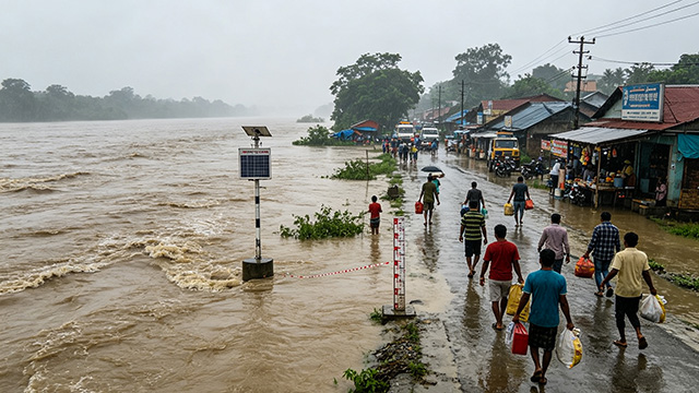
Recently, due to concentrated seasonal monsoon rains, flood prevention conditions have become severe in the Karbi Anglong region of Assam, northeastern India. The water level of the Diphu River in the area has risen sharply and exceeded the official danger warning threshold. Local authorities have issued an urban flash flood warning and activated round-the-clock flood emergency duty across the region.
On-site flood control reports show heavy continuous rainfall has drastically increased runoff in the Diphu River. Water overtopped the embankments and flooded core zones of Diphu Town. Residential areas, local markets and major urban roads suffered waterlogging. Many houses in low-lying zones were inundated, severely disrupting residents’ daily life and production. Meteorological forecasts indicate short-duration intense rainfall will continue. The Diphu River water level may climb further, keeping risks of sudden flash floods and river embankment breaches high, and putting immense pressure on flood prevention and evacuation.
To accurately track hydrological conditions and contain flood expansion, local water conservancy and emergency authorities rapidly deployed hydrological monitoring stations. These stations deliver 24/7 continuous dynamic monitoring of Diphu River water level, flow rate and rainfall data to track hydrological trends in real time. Warning alerts are sent to residents along the river to remind communities in low-lying areas to prepare for emergency evacuation and protect people’s lives and property.
This urban flash flood event in India highlights core challenges for flood control on small and medium mountain rivers: concentrated monsoon rainfall, fast catchment runoff, rapid water level surges and an extremely short early-warning window. Conventional manual patrol and intermittent monitoring struggle to capture sudden water conditions accurately, often creating monitoring blind spots and delayed alerts, which greatly increases the difficulty of flash flood disaster prevention. Flash floods and rapid river level rises frequently occur in monsoon climate zones across South and Southeast Asia. An all-weather, automatic, high-precision real-time water & rainfall monitoring and intelligent early warning system has become a core requirement for regional flood mitigation.
As a global smart water conservancy and flood control solution provider, Four-Faith IoT has years of expertise in hydrological monitoring and flash flood early warning. Targeting flood control pain points of rivers in overseas monsoon regions, we have developed a full-chain flash flood monitoring and early warning system integrating front-end intelligent sensing, stable data transmission, cloud-based intelligent analysis and automatic alert delivery. Suitable for diverse scenarios including small & medium mountain rivers, urban watercourses and suburban watersheds, the solution relies on water level sensors, rainfall monitoring equipment and industrial RTU telemetry terminals to realize unattended 24-hour data collection. It captures subtle water level changes and rainfall dynamics accurately. Combined with threshold-based intelligent judgment, the system automatically triggers multi-level warnings, effectively solving pain points of delayed monitoring, incomplete coverage and slow response in traditional solutions.
Tailored for flood scenarios in India and South Asia with heavy rainfall, frequent flash floods and remote river reaches, Four-Faith IoT’s smart flood control solution features strong adaptability, high stability and simple deployment. It enables rapid construction of a regional hydrological monitoring network, helping local water and emergency departments achieve early detection, early warning and early response. The system significantly cuts emergency response time, precisely mitigates disaster losses caused by flash floods and river overtopping, and builds a digital safety barrier for overseas urban river flood mitigation and watershed water security management.